Electronic Travel Aid (ETA) System for Visually Impaired People
Mr. P. S. Ranaweera, H. R. Madhuranga, F. A. S. Fonseka, M. L. D. Karunathilaka.
Visually impaired people face unique challenges in their day to day life while navigating in unfamiliar public locations. Using a walking stick relies on trial and error, particularly in unfamiliar locations. Also from a walking stick the user can only identify obstacles which are touching the stick and cannot identify the obstacles which are above his waist height. Electronic Travel Aids (ETAs) are devices that use sensor technology to assist and improve the blind users mobility in terms of safety. In this context, we implement a system whose objective is to give blind users the ability to move around in unfamiliar environment, whether indoor or outdoor, through an interface specifically designed to cater the visual imperfections. This ETA system grants the user the ability to travel independently with an automated alerting system designed for emergencies. The obstacles are detected using image processing and distance sensing through IR sensors. A navigation system was developed to assist the user via web access.
Key Words:
Electronic Travel Aids, GPS, Image Processing, Infra-red, Visually Impaired
Overview
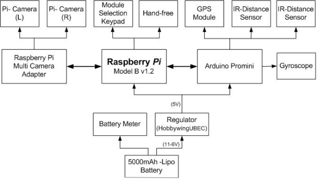
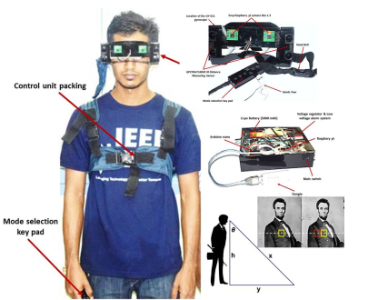
The system consists of mainly three parts. Camera module and sensor network, Audio acknowledgment system and Navigation system.
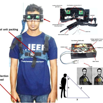
- Camera Module and Sensor Network: The main part of the system is a camera module with a related sensor network for recognizing an object which lies on his or her way. The distance for detected object and the speed of the dynamic objects are being calculated by this part. Image processing technique is the main object identification method in this device and it is being used for the continuous object processing along the blind persons way and then users are receiving audio acknowledgments if the identified objects are below the pre-defined range. The camera module consists of two Raspberry Pi Rev 1.3 cameras which are capable of capturing 1080p30, 720p60 and 640 x 480p60=90 video and 2592 x 1944 pixel resolution for static images. Raspberry Pi 3 model B v1.2 microcontroller which is running on Raspbian operating system board is used for image processing. The sensor array consist of three SHARP GP2Y0A710K0F infrared distance measurement sensors which works on the principle of optical triangulation.
- Audio Acknowledgment System:This system is used to supply voice commands related to objects or obstacles which are detected by the sensor array or image processing to the user of the ETA. The information regarding the current location of the user or the destinations that the user requires to reach are notified by the audio acknowledgments using the eSpeak library.
- Navigation System:GY-NEO6MV2 GPS Module is used to get the current GPS coordinates of the user and Arduino Pro Mini ATmega328 micro-controller has been used to serially communicate with raspberry pi module and obtained coordinates are sent to Google MAP API to find out the current location. The nearby places that user needs to reach can be found using Google place API. The directions for a selected place can be found using the Google direction API. The complete system architecture is illustrated in the above Figure.
Summary
Proposed concept in this paper is a novel approach for providing navigation for visually impaired people. The advantage of this system lies in the fact that it can provide multi-functional solutions to blind people around the world. The proposed system is a combination of various working units which collectively produce a real-time system that detects obstacles while making navigation of the blind people moresafe and secure.
The implemented system uses two cameras and two IR sensors for obstacle detection. Camera output has a clear identification of the environment and Infrared sensors with analog outputs have excellent repeat sensing accuracy. It is possible to ignore immediate background objects, even at long sensing distances because switching hysteresis is relatively low. The implemented system was planned to introduce GPS for locating the position of the user and navigate him to the selected destination with directions. Location of the user is tracked using GPS system and the coordinates are integrated with Google Maps API to get the address of the current location. Another implemented feature is to give directions to a selected place around the current location of the user. The important feature in the navigation system is the alerting a third party about an emergency for the user. So this will send an SMS to the predefined third party (relation/police station) conveying the emergency.
Updates
Phase #2
Project Video
Publications
- Ranaweera, P. S., S. H. R. Madhuranga, H. F. A. S. Fonseka, and D. M. L. D. Karunathilaka. “Electronic travel aid system for visually impaired people.” In 2017 5th International Conference on Information and Communication Technology (ICoIC7), pp. 1-6. IEEE, 2017.